

HISTORIC PICTORIC
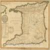
Trinidad 1800 Historical Map Print - Laurie & Whittle Atlas Reproduction - 57in x 44in
NZ$1,054.78
NZ$1,757.97
-
 Order within to get between
-
 Tracked Shipping on All Orders
-
 14-Day Returns
- Secure Payments
-
 24/7 Customer Support
Description
- Hand-colored engraved map of Trinidad from 1800, showing political divisions and population data in detailed tables.
- Atlas plate from Robert Laurie & James Whittle's acclaimed Universal Atlas, a major cartographic work of the early 19th century.
- Historical map reproduction ideal for collectors, offices, studies, and anyone interested in Caribbean geography and colonial-era cartography.
- FINE ART PRINT QUALITY: Printed on heavyweight 230gsm matte paper with archival gicle inks for crisp detail, rich tonal depth, and long-lasting display quality suitable for home, office, or gallery-style framing.
- PRINTED IN THE USA: Professionally printed on heavyweight matte paper and carefully packaged in a durable protective tube for safe delivery. Many sizes fit widely available standard frames. Each artwork is digitally restored to reduce age-related imperfections while preserving the historic texture, detail, and character of the original map.
Plan of the isle of Trinidad, from actual surveys made in the year 1797. Published 12th Decr. 1800 by Robert Laurie & James Whittle, No. 53 Fleet Street, London. Engraved by George Allen, 19 Shoe Lane, Fleet Str.|(A new universal atlas, exhibiting all the empires, kingdoms, states, republics, &c. &c. in the whole World; being a complete collection of the most approved maps extant; corrected with the greatest care, and augmented from the last edition of D'Anville and Robert (de Vaugondy) with many improvements by Major James Rennel, and other eminent geographers, including all the tracks and new discoveries of the British circumnavigators, Biron, Wallis, Carteret, Captain James Cook, Vancouver, Perouse, &c. &c. 6th Ed. ... London, R. Laurie & J. Whittle, 1804)
We print high quality reproductions of historical maps, photographs, prints, etc. Because of their historical nature, some of these images may show signs of wear and tear - small rips, stains, creases, etc. We believe that in many cases this contributes to the historical character of the item.
Shipping and Returns
- We offer tracked shipping on all orders. Tracking information will be shared as soon as the order is dispatched.
- Please check the delivery estimate before adding a product to the cart. This is displayed for every product on the website.
- Available shipping methods and charges will be displayed at the time of checkout, depending on your exact location.
- All customers are entitled to a return window of 14 days, starting from the date of delivery of the product(s).
- Customers are advised to read our return policy for details of the return process, eligibility, refunds as well as cancellations or exchanges.
- In case of any issues or concerns about Shipping or Returns, please contact us and we will be happy to help.
Historic Pictoric.
Trinidad 1800 Historical Map Print - Laurie & Whittle Atl...
NZ$1,054.78
NZ$1,757.97